Dartmouth Greenway Circular Dart Valley Trail
One of the areas truly great walks, this day-long ramble follows the wooded banks of the broad and beautiful Dart Estuary.
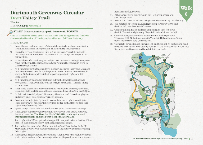
DIFFICULTY: Moderate
START: Mayors Avenue car park. Dartmouth, TQ6 9NG
DIRECTIONS:
1. Leave the carpark and turn right along the waterfront. Just past Station Restaurant turn left onto pontoon. Take the ferry to Kingswear.
2. From the ferry at Kingswear turn left up the road. Turn left opposite the village stores and follow the yellow-marked footpath alongside the railway line.
3. At the Higher Ferry slipway, turn right over the level crossing then up the road. Just beyond the public toilets, bear right up the ramp and steps to climb through woods.
4. At T-junction, turn left along drive, signed ‘Greenway Ferry and Maypool’ then at main road take footpath opposite and to left and down through woods. At the tarmac drive take footpath opposite to right, and into Long Wood.
5. At T-junction in woods, turn left and follow the track through woods above river. Track eventually curves to right and uphill. Turn left along terrace pass.
6. After steep climb, turn left over stile and follow path. Part way downhill, cross into field to right over stile and continue down along the hedge line.
7. At field exit turn left, signed ‘Greenway Gardens ¾m’. Pass through gate and down track past houses. Turn left at road.
8. Continue through gate. By bench in open field, turn right through gate. Once over brow of hill, bear left down field edge path. At the bottom turn right along Greenway Drive.
9. By the Lodge House turn left down road to quay. Cross river via ferry.
10. Walk up the road through Dittisham, after 350m, turn sharp left along Rectory Lane. For The Ham Car Park TQ6 0HS, walk up the road through Dittisham past the Ferry Boat Inn, after 350m
11. Turn right after 250m up track along public footpath. After a further 100m, turn left over stile and follow path up along hedge edges.
12. Turn left at the road, after 250m, turn left signed ‘Permissive Path Old Mill Creek’. Follow well-used track initially the follow waymarkers along field edges.
13. Where path meets Green Lane, turn left. After 200m, turn right down path which leads to river. After crossing a stile cut diagonally down across next field, and through woods.
14. At bottom of steps bear left, and then left again where you join further track.
15. At Old Mill Creek cross over bridge and follow road up out of valley.
16. AT-junction at Townstal, turn right along Archway Drive and the first left onto Townstal Crescent.
17. Cross main road at pedestrian crossing and turn left down the hill. Turn first right along Church Road and down the hill.
18. Cross at next junction down Mount Boone. Fork right down Townstal Hill. At the junction with Vicarage Hill carry straight on down the narrow lane Clarence Hill.
19. Turn right down steps of Brown’s Hill and bear left. At the bottom, head towards the Church tower, along Foss St. At the road turn left. Cross into Royal Avenue Gardens and bear left into car park.